Moses Spring–Rim Trail Loop
Easy–Mod
2.2 mi+400 ft~1.5 hr
The classic east-side loop through Bear Gulch Cave and past the reservoir, with rock formations throughout. No permit.
 National
California · Park 42 / 64
Half of an ancient volcano, its other half 195 miles away on the far side of the San Andreas Fault, now a stronghold for the California condor.
Roughly 23 million years ago, a volcanic field erupted near present-day Lancaster, California. Tectonic forces along the San Andreas Fault have since split that field in two and dragged this half nearly 200 miles northwest to its current location, a geologic fact confirmed only in 1976 by matching rock signatures on both sides of the fault. What's left is a landscape of jagged rhyolite and tuff spires, talus caves formed by boulders that jammed narrow canyons, and some of the best rock climbing in central California.
Pinnacles is also one of the most important release sites for the California condor, one of the rarest birds on Earth, reintroduced here in 2003 after the species nearly went extinct in the 1980s. The park has no road connecting its two entrances, east and west, meaning a drive between them takes roughly two hours around the outside, though experienced hikers can cross on foot in a long day.
Come for the chance to see a condor riding a thermal over the High Peaks. Stay for the talus caves, dark and cool even on the hottest afternoon. Read the story, trust the live data above for what is open today, and when you leave, mark it visited.

The spellbinding geology here is far from over: geologists estimate that Pinnacles is still moving northwest at an average of two inches a year.Adapted from National Geographic's account of Pinnacles' ongoing tectonic drift
Six ways to spend your time, from a condor-watching climb to a flashlight-lit scramble through a talus cave.
The park's best chance at spotting a California condor riding thermals over the jagged rock spires.
The signature hikeA talus cave formed by boulders jammed into a narrow canyon, sometimes closed seasonally to protect nesting bats.
Half day · bring a flashlightA similar talus cave on the park's west side, with a rock scramble and narrow, dark passages requiring a light source.
Half day · bring a flashlightA small reservoir tucked in the rocks, a peaceful stop after the caves and a good turnaround point for shorter hikes.
Everyone · half day loopOne of central California's best climbing destinations, though the volcanic rock can be soft and crumbly in places.
Climbers · experience requiredThe park's remote location provides dark skies well away from major city light pollution.
Stargazers · after darkAnswer a few questions right here. We'll map your day, stop by stop, with a route, timings, weather, and a packing checklist grounded in real park data. No account, no leaving this page.
⚡ In a hurry? Adventure Light 5 questions →Every trail rated honestly, with distance, climb, and a note on which side of the park each one belongs to.
The classic east-side loop through Bear Gulch Cave and past the reservoir, with rock formations throughout. No permit.
A west-side loop past Machete Ridge and through Balconies Cave, requiring a flashlight for the cave section. No permit.
A climb with good odds of spotting condors, connecting to the High Peaks Trail at the top. No permit.
A steep, narrow trail through the jagged High Peaks with handrails on the exposed sections, the park's best condor-viewing route. No permit.
A gentler approach to Balconies Cave from the west entrance, following a creek bed most of the way. No permit.
A full crossing of the park on foot, since no road connects the two entrances. A shuttle or ride back is needed; permit only for overnight camping.
No permit for day hikes · free backcountry permits for overnight camping · no road connects the east and west entrances inside the park
Tap any animal to learn its story. Soon, the app will let you log what you spot and keep a life list for every park.
Reintroduced to Pinnacles in 2003 after the species nearly went extinct in the 1980s, with a nine-and-a-half-foot wingspan making it North America's largest flying land bird.
Ranges throughout the park's rugged terrain, rarely encountered by day hikers.
Males wander in search of mates each autumn, a common and harmless sight on park trails at dusk.
Found in the park's seasonal streams and pools, a threatened species benefiting from the park's protected habitat.
A rare insect species with a distribution centered almost entirely on the Pinnacles area.
Found throughout the park's chaparral and oak woodland, especially visible at dawn and dusk.
Roosts in the park's talus caves, occasionally prompting seasonal cave closures during sensitive nesting periods.
Covers much of the park's lower elevations, a fire-adapted community of tough, drought-resistant shrubs.
Common on the park's drier, rockier slopes, adapted to the thin soils found among the volcanic spires.
Grows among the rocks of the High Peaks area, providing food for numerous pollinator species.
The park's spring wildflower bloom draws photographers to the lower elevation trails during the cooler months.
Common throughout the park's oak woodland zones, tolerant of the region's hot, dry summers.
Widespread along many trails, especially the lower sections; learning to identify it is genuinely useful here.
Pinnacles' rock formations originated in a volcanic field 195 miles southeast of their current location, moved here by movement along the San Andreas Fault.
The park is estimated to still be moving northwest at an average of two inches a year, an ongoing geologic process.
California condors were reintroduced here in 2003, part of a broader effort that has grown the total wild population from near-extinction in the 1980s.
Pinnacles became a full national park only in 2013, upgraded from a national monument status held since 1908.
The questions people actually ask, answered from the park’s own current guidance. Fees and permit rules change every year, so each answer links back to the National Park Service page it came from.
A private vehicle pass is $30, a motorcycle is $25, and people arriving on foot or bike pay $15 each. There's no cash accepted at Pinnacles, so bring a card or use a mobile payment option. Source: NPS.gov
No reservation or permit is needed for day use at Pinnacles. The only time you need to book ahead is for camping, which goes through recreation.gov. Keep in mind the west entrance gate is only open 7:30 a.m. to 8 p.m. and has no overnight parking, while the east side allows trail access around the clock outside the campground. Source: NPS.gov
The High Peaks area is your best bet, reachable from either entrance though it's a strenuous hike, and the ridge southeast of the campground is another spot where condors are regularly seen soaring on morning thermals. The park has also set up two spotting scopes on the Bench Trail near the visitor center. Early morning and early evening are the best times, but condors range widely and there's no guarantee one shows up on a given day. Source: NPS.gov
Stories, guides, and hard-won tips from the trail. The full Pinnacles deep dive lives on the blog.
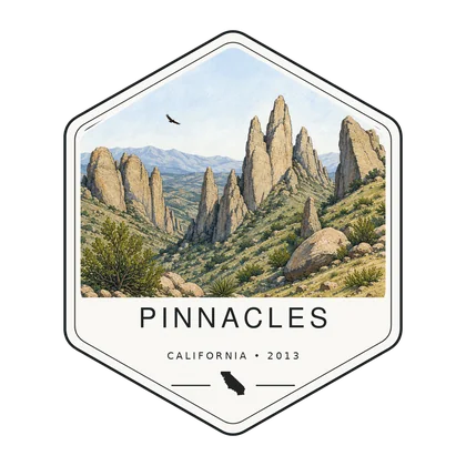
Log the visit, keep your story, and watch the map of all sixty-four fill in behind you. Every visit has a keepsake worth holding.
See the full map and track every park you have visited.
View the map → PlanTurn Pinnacles into a road trip with a custom, day-by-day itinerary.
Start planning → Go deeperPinnacles spent over a century as a national monument before becoming the 59th national park in 2013.
Read it → Explore moreFind your next park anywhere in the country.
Browse parks →
Offline maps, your passport, and every park in your pocket on the trail.
Join the waitlist →
The printed edition, part atlas, part journal, one story per park.
Notify me →Park-guide posters, enamel stamps, and the passport book to fill in.
Visit the shop →Field Notes
The parks do not perform for anyone. They stood here before the road, and they will stand here after it.