Guadalupe Peak Trail
Strenuous
8.5 mi+3,000 ft6–8 hr
A steep, switchback climb to the highest point in Texas, with steady exposure and a final rocky push near the summit. No permit.
 National
Texas · Park 43 / 64
The highest point in Texas, rising out of the Chihuahuan Desert as the fossil remains of an ancient Permian reef.
Guadalupe Peak, at 8,751 feet, is the highest point in Texas, and it's not a typical mountain at all but the exposed remnant of a massive Permian-age reef that formed at the edge of a tropical sea roughly 260 million years ago, long before the Rocky Mountains existed. El Capitan, the sheer limestone cliff at the range's southern tip, served as a landmark for travelers for centuries, from Indigenous peoples through the Butterfield Overland Mail stagecoach route in the 1850s.
McKittrick Canyon, often called the most beautiful spot in Texas, cuts a green ribbon through the surrounding desert, with maple trees that turn brilliant red and orange each fall in a display that draws visitors from across the state during a narrow window in late October and November. The canyon's gate closes strictly at dusk, one of the more firmly enforced rules in the park, since the access road beyond it is otherwise unlit and remote.
Come for the highest point in the state. Stay for McKittrick Canyon, if your timing allows it. Read the story, plan around the gate hours, and when you leave, mark it visited.

McKittrick Canyon is a confluence of diversity: trees of the east, north, and west, the grasses of the plains, and the cactus and succulents of the desert join here.Adapted from National Park Service interpretive writing on McKittrick Canyon
Six ways to spend your time, from the highest point in Texas to a canyon that looks nothing like the desert around it.
An 8.5-mile round trip to the highest point in Texas, with a metal marker at the top and views stretching for miles.
The signature climbA sheer limestone cliff visible from Highway 62/180, a historic landmark for travelers long before the park existed.
Everyone · roadside viewA trail into a lush canyon with maple trees, especially spectacular during the narrow fall color window in late October.
The signature canyon · gate closes at duskExhibits on the park's geology and history, and the starting point for the Guadalupe Peak and Devil's Hall trails.
Everyone · 30 minA rocky scramble along a dry streambed to a narrow natural passage between towering canyon walls.
Half day · moderate scramblingA remote field of white gypsum dunes on the park's western side, a striking contrast to the surrounding mountains.
Half day · high-clearance recommendedAnswer a few questions right here. We'll map your day, stop by stop, with a route, timings, weather, and a packing checklist grounded in real park data. No account, no leaving this page.
⚡ In a hurry? Adventure Light 5 questions →Every trail rated honestly, with distance, climb, and a reminder to carry serious water in this exposed desert range.
A steep, switchback climb to the highest point in Texas, with steady exposure and a final rocky push near the summit. No permit.
A rocky streambed scramble ending at a narrow natural passage between sheer canyon walls. No permit.
A gentle loop near the canyon entrance, good for a short taste of the canyon without the longer hike. No permit.
A longer walk up the canyon to a small cave-like grotto and the historic Pratt Cabin. Gate closes strictly at dusk. No permit.
A loop from Frijole Ranch to a rare desert spring, one of the park's better birding spots. No permit.
A remote climb into the high backcountry connecting to trails across the range. Backcountry permit required for overnight camping.
No permit for day hikes · free backcountry permits for overnight camping · McKittrick Canyon gate closes strictly at dusk
Tap any animal to learn its story. Soon, the app will let you log what you spot and keep a life list for every park.
Reintroduced to the range, now working the steep limestone cliffs throughout the park, occasionally visible from lower trails.
Present throughout the range's rugged canyons and high country, rarely encountered by day hikers.
Nests on the range's sheer cliffs, occasionally visible riding thermals near El Capitan and Guadalupe Peak.
Common throughout the park's lower elevations, especially visible near Frijole Ranch and McKittrick Canyon.
Found near the park's rare, permanent water sources, including the springs feeding McKittrick Canyon.
One of the largest wasps in North America, with an intensely painful sting rarely directed at people, common in the desert lowlands.
A nimble, nocturnal relative of the raccoon found in the park's rocky canyons, almost never seen by day visitors.
A relic of the last Ice Age, surviving in the cool, moist microclimate of McKittrick Canyon and producing the park's famous autumn display.
A defining plant of the Chihuahuan Desert, common across the park's lower, drier elevations.
Found in the park's higher elevations, identifiable by its distinctive checkered, alligator-skin-like bark.
Spends decades as a low rosette before sending up a single towering flower stalk once, then dies.
Found in the park's shadier canyons, notable for its smooth, peeling reddish bark.
A yucca relative common throughout the park's grassland zones, historically used for fiber and food.
Guadalupe Peak, at 8,751 feet, is the highest point in the state of Texas.
The range is the exposed remnant of a Permian-age reef that formed at the edge of a tropical sea roughly 260 million years ago.
McKittrick Canyon's bigtooth maples are relics of a much wetter, cooler climate from the last Ice Age, surviving today only in this sheltered microclimate.
El Capitan served as a landmark for travelers on the Butterfield Overland Mail stagecoach route through the 1850s.
The questions people actually ask, answered from the park’s own current guidance. Fees and permit rules change every year, so each answer links back to the National Park Service page it came from.
A standard pass is $10 per person, ages 16 and up, and covers 1 to 7 consecutive days. If you'll visit more than once a year, the park's own annual pass costs $35 and is good for 12 months from the month you buy it. Source: NPS.gov
You don't need a permit for day hiking, including the trail up Guadalupe Peak. Overnight backpacking is different, you need a Wilderness Use Permit, which runs a $6 non-refundable reservation fee plus $6 per person per night, reservable up to three months ahead or picked up as a walk-up permit at Pine Springs Visitor Center. Source: NPS.gov
The Guadalupe Peak trail is an 8.5 mile round trip with about 3,000 feet of elevation gain, climbing what the park calls the Top of Texas. The National Park Service rates it very strenuous, so plan on a full day out there and start early. Source: NPS.gov
Stories, guides, and hard-won tips from the trail. The full Guadalupe Mountains deep dive lives on the blog.
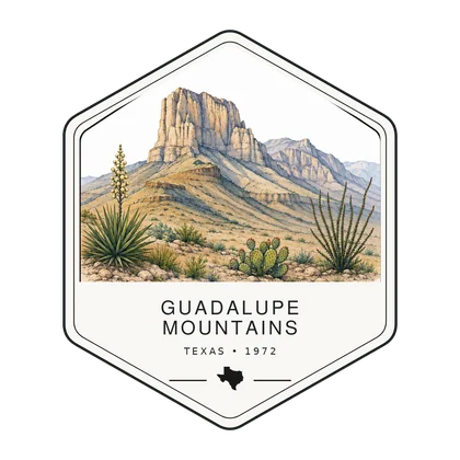
Log the visit, keep your story, and watch the map of all sixty-four fill in behind you. Every visit has a keepsake worth holding.
Thirty minutes north into New Mexico: from the highest point in Texas to a cave that breathes.
Open Park 26 → The collectionSee the full map and track every park you have visited.
View the map → PlanTurn Guadalupe Mountains into a road trip with a custom, day-by-day itinerary.
Start planning → Go deeperThe highest point in Texas is an 8.5-mile hike ending at a stainless steel pyramid nobody expects to find on a desert mountaintop.
Read it →
Offline maps, your passport, and every park in your pocket on the trail.
Join the waitlist →
The printed edition, part atlas, part journal, one story per park.
Notify me →Park-guide posters, enamel stamps, and the passport book to fill in.
Visit the shop →Field Notes
The parks do not perform for anyone. They stood here before the road, and they will stand here after it.